Connect this guide with the rest of your visit in the Antalya trip planner. Read how the research is made and what its sources establish.
At a glance
Start here
- Begin your interpretation at the harbour because the port explains the old town's location.
- Read Hadrian's Gate as a surviving piece of a defended city, not an isolated photo stop.
- Use Yivli Minare and the Mevlevihane complex to understand the Seljuk and later civic centre.
- Notice house fronts, courtyards, street widths and changes in level as evidence of daily urban life.
01
The harbour explains why the city is here
Kaleiçi is often introduced through its lanes, yet Antalya Metropolitan Municipality begins its account with the old harbour and the protected settlement around it. The harbour is not scenery attached to the city; it is the reason a defensible trading settlement could grow on this part of the coast. Looking uphill from the water makes the steep approaches, tight footprint and relationship between port and upper town immediately legible.
The municipality identifies the ancient city as Attaleia and follows its development through Roman, Byzantine, Seljuk and Ottoman rule. Those labels should not be imagined as clean layers stacked like a museum diagram. Buildings were repaired, religious functions changed and useful routes persisted. The productive question is therefore not which era owns Kaleiçi, but how each era adapted a port city it inherited.
- Look back from the harbour to see how abruptly the inhabited ground rises.
- Trace connections between the waterfront, gates and commercial streets.
- Treat the modern marina as a working descendant of the historic port, not proof that everything visible is ancient.
02
Walls shaped the plan even where they disappeared
The municipality's historical description and route map repeatedly orient the old town through fortifications, towers and gates. Surviving pieces are incomplete, but the former defended perimeter still helps explain why streets turn sharply and why movement concentrates at particular entrances. A vanished wall can remain influential long after its masonry has been absorbed, demolished or separated from later buildings.
This changes how to read the boundary between Kaleiçi and the modern city. Broad roads outside the core have a different relationship to the former fortified settlement. When a lane narrows or its level changes near the perimeter, the shape may preserve a practical response to defence, terrain or access.
- Use the municipality's mapped route to locate surviving gates and wall fragments.
- Notice bends and bottlenecks at the old town's edges.
- Do not assume that a restored-looking surface dates from the period whose plan it follows.
03
Hadrian's Gate tells two survival stories
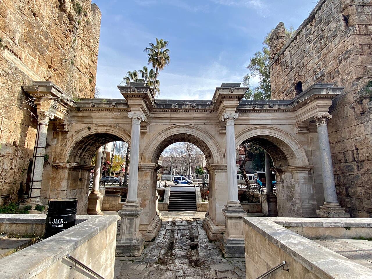
Hadrian's Gate marks the Roman city more clearly than almost any other surviving entrance. The Ministry of Culture and Tourism's Culture Portal dates it to Emperor Hadrian's visit in AD 130 and describes its three arched openings. Its scale expresses ceremony as well as passage: this was an arrival designed to be seen, not simply a gap cut through a wall.
Its later history matters just as much. The official account says the gate was enclosed within the city wall and brought back to view in 1882. In other words, survival was partly a result of disappearance. That fact is a useful warning against reading present visibility as continuous prominence; monuments can be obscured, reused and rediscovered before becoming symbols of the city.
- Compare the three arches rather than treating the monument as a flat façade.
- Look for the relationship between the gate and adjacent wall fabric.
- Remember that its modern landmark status followed a long period of enclosure.
04
Yivli Minare announced a different civic skyline
Yivli Minare shifts the visual centre away from the Roman gate toward Antalya's Seljuk history. The Culture Portal describes the fluted brick minaret, its tile decoration and its place within a larger building complex. The municipality likewise uses it as a principal reference point in explaining the historic city. Its importance lies not only in age or height, but in how a new ruling culture made itself visible above inherited streets.
The portal notes that the Yivli Minare complex has been on Türkiye's UNESCO World Heritage Tentative List since 2016. Tentative status is not World Heritage inscription, and that distinction should remain clear. What the nomination does underline is the value of reading the minaret together with the mosque and surrounding structures rather than isolating its recognisable silhouette from the institutional landscape below.
- Observe the fluting, brickwork and traces of tile as material choices.
- Find the surrounding complex before moving on to another landmark.
- Describe the site as tentative-listed, not as an inscribed World Heritage property.
05
The Mevlevihane reveals a connected complex
The official Turkish Museums page places the Mevlevihane Museum within the Yivli Minare complex alongside a bath and tombs. Its rooms now interpret Mevlevi culture, but the spatial lesson is broader: historic religious and civic life was organised through connected buildings with different functions, not through freestanding monuments consumed one at a time.
Walk around the complex slowly enough to register thresholds, courtyards and the proximity of unlike structures. The museum display can supply names and functions that the exterior cannot. Conversely, stepping back outside shows why an object-by-object museum visit is incomplete. The surrounding urban relationships explain how institutions occupied the old city's centre and how later preservation turned working spaces into interpreted heritage.
- Read the bath, tombs, museum rooms and minaret as neighbours.
- Separate what the current display interprets from the building's earlier uses.
- Check the official museum page for current access before planning around an interior visit.
06
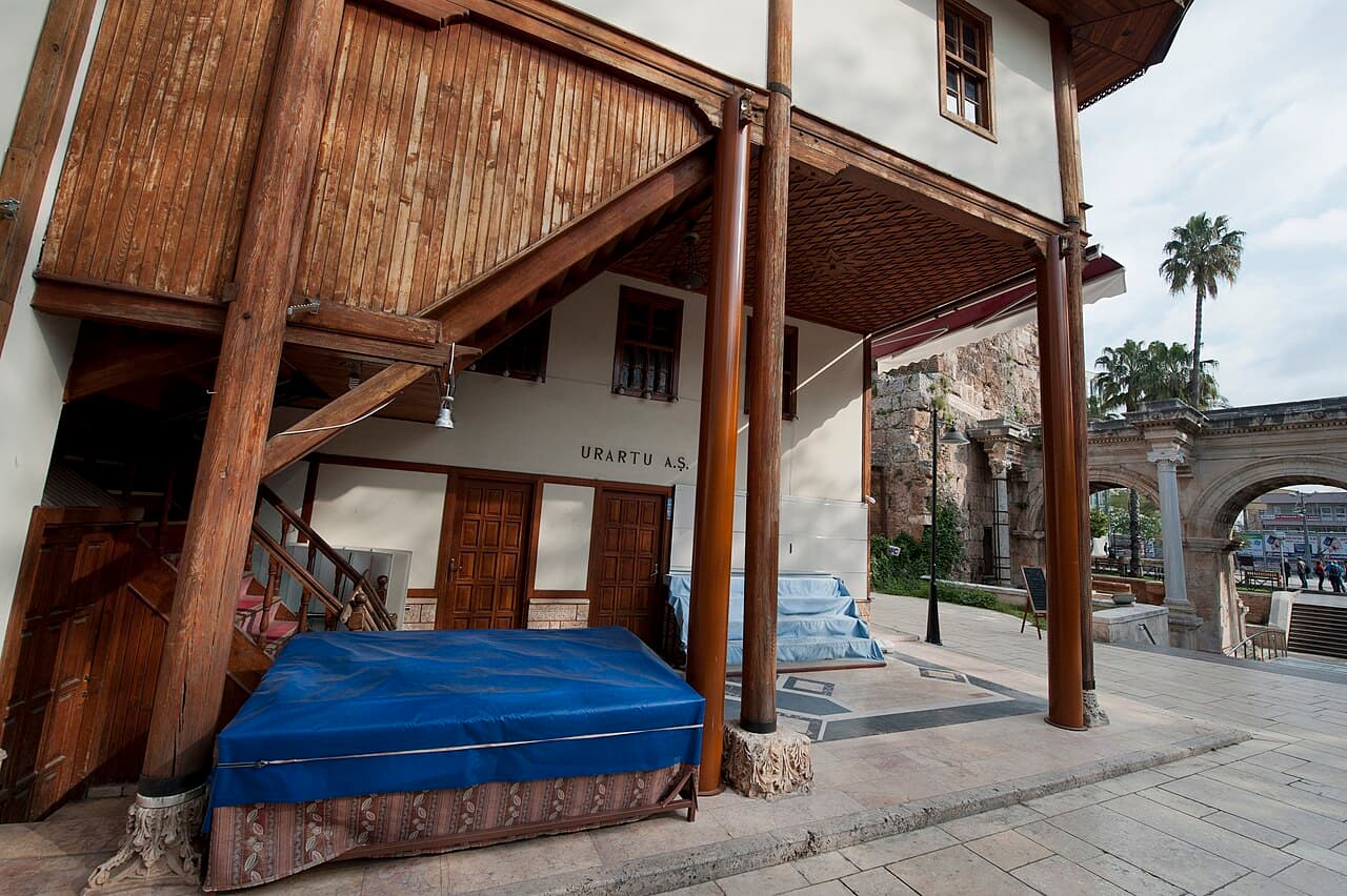
Houses record daily life more quietly
Monuments provide dates and patrons, while the old town's houses reveal repeated decisions about shade, privacy, ventilation and family space. The municipality describes the characteristic streets and houses as essential parts of Kaleiçi's protected urban fabric. Their cumulative value is easy to miss because no single doorway carries the instant authority of a Roman gate or Seljuk minaret.
Do not assign an exact age or function to a property from appearance alone. Restoration, commercial conversion and reused materials complicate the façade. Instead compare patterns: upper floors over lanes, indirect entrances, hidden courtyards and street widths changing with the slope. They make the neighbourhood a social landscape rather than a façade collection.
- Compare several houses before drawing conclusions from one restored example.
- Notice how built form negotiates sun, slope and privacy.
- Respect residential entrances and avoid treating occupied space as an open exhibit.
07
Read the old town without freezing it in time
Kaleiçi remains a contemporary neighbourhood of homes, museums, hospitality businesses, religious buildings and public routes. The official sources present a long sequence of change, not a single golden age to which every surface should belong. Modern use is therefore part of the story, although it also makes careful conservation and respectful visitor behaviour more important.
A useful visit alternates between close observation and wider orientation. Examine a gate or wall joint, then relocate it in relation to the harbour and skyline. Read an official panel, then test that explanation against the ground. Photograph architectural details without blocking a doorway or turning residents into background subjects. The reward is not a checklist completed; it is a clearer account of why Antalya's old centre still feels structurally different from the city around it.
- Pair official interpretation with direct observation of urban relationships.
- Give active religious and residential spaces the courtesy their present use requires.
- Leave room for uncertainty when a building's fabric spans more than one period.
Useful answers
Reader questions
Is Kaleiçi only an Ottoman old town?
No. The municipality traces the settlement through ancient Attaleia and Roman, Byzantine, Seljuk and Ottoman periods. Ottoman houses are prominent, but the harbour, fortifications, Hadrian's Gate and Yivli Minare expose a much longer urban sequence.
Sources: Antalya Metropolitan Municipality; Türkiye Culture Portal, Ministry of Culture and Tourism; Türkiye Culture Portal, Ministry of Culture and TourismWhy did Hadrian's Gate survive?
The Culture Portal says the gate was enclosed within the city wall and exposed again in 1882. Its survival cannot be reduced to one cause, but that enclosure helps explain why substantial Roman fabric remained to be rediscovered.
Sources: Türkiye Culture Portal, Ministry of Culture and TourismIs Yivli Minare a UNESCO World Heritage Site?
No. The Culture Portal states that the Yivli Minare complex has been on Türkiye's Tentative List since 2016. A tentative listing is a preliminary national nomination step, not inscription on the World Heritage List.
Sources: Türkiye Culture Portal, Ministry of Culture and TourismWhat is the best way to understand Kaleiçi's layout?
Start at the old harbour, identify the former fortified boundary and gates, then use Yivli Minare to orient the upper town. The municipality's historical map helps connect surviving monuments to the streets instead of viewing each one in isolation.
Sources: Antalya Metropolitan MunicipalityRead the evidence
Sources and further reading
These sources support the relevant sections above. Plans and comparisons are editorial suggestions. Check operators for current arrangements.
- Kaleiçi ↗Antalya Metropolitan Municipality · Research date 14 September 2026
The harbour-led settlement history, Attaleia's successive periods, fortifications, historic routes, Yivli Minare and the protected pattern of streets and houses.
- Hadrian Kapısı - Antalya ↗Türkiye Culture Portal, Ministry of Culture and Tourism · Research date 14 September 2026
The gate's association with Hadrian's AD 130 visit, three-arch form, later enclosure and exposure in 1882.
- Yivli Minare Camii - Antalya ↗Türkiye Culture Portal, Ministry of Culture and Tourism · Research date 14 September 2026
The Seljuk monument's fluted brick and tile construction, wider complex and UNESCO Tentative List status since 2016.
- Mevlevihane Müzesi ↗Turkish Museums, Ministry of Culture and Tourism · Research date 14 September 2026
The museum's place in the Yivli Minare complex, neighbouring bath and tombs, and current interpretation of Mevlevi culture.